Victoria has a staggering number of hiking trails that almost always reach something amazing.. and radically different. From Goldstream Park's spawning salmon to the marvellous Goldstream Train Trestle. You can hike dozens of beautiful, coastal kilometres in Juan de Fuca Provincial Park and East Sooke Regional Park. Victoria is a hiker's paradise.
TheWestCoastTrail
The West Coast Trail traces a route along a 75 kilometre section of Vancouver Island's hostile west coast. The trail looks over the Graveyard of the Pacific, home to hundreds of shipwrecks over the centuries. The Graveyard of the Pacific necessitated the construction of the West Coast Trail to save lives from the frequent shipwrecks.
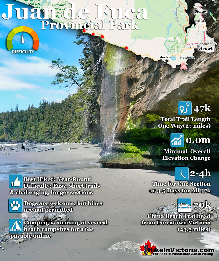
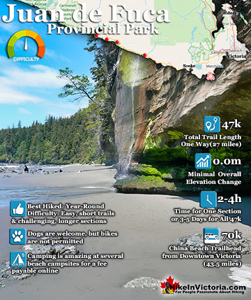
The Juan de Fuca Trail is a beautiful wilderness trail that hugs the west coast of Vancouver Island between Jordan River(north of Sooke) and Port Renfrew. Established as a provincial park in 1995, the Juan de Fuca Trail traces its origins to the 1889 telegraph line that connected Victoria and Bamfield. The telegraph line connected Bamfield to the British Empire via a transpacific cable.
This cable required patrolmen to routinely check the line. Linesmen were housed in in cabins along the route. The Juan de Fuca Trail and the West Coast Trail share this function, however, the West Coast Trail continued to function as a lifesaving trail, long after what would eventually be the Juan de Fuca Trail fell into disuse. Decades later, in the 1970's, with the growing popularity of the West Coast Trail, a renewed interest in the area continued to grow. Public interest in the area collided with logging companies pushing into the area. The Victoria Sierra Club filed lawsuits in an attempt to halt logging in the Sombrio Creek and Parkinson Creek regions. The Victoria Sierra Club was successful in halting the logging and the "West Coast Strip" was preserved as a future park. Finally in the 1990's the provincial government acquired and set aside land for the proposed provincial park. The beautiful 47 kilometre Juan de Fuca Trail we see today was finally constructed and officially designated as the Juan de Fuca Marine Trail in Juan de Fuca Provincial Park. The trail and the park are simply known as the Juan de Fuca Trail. The park is named after Juan de Fuca Strait, the large channel of water that separates Vancouver Island from the mainland of North America. Juan de Fuca Strait is also the international boundary between Canada and the United States. Juan de Fuca was a Greek sailer and explored the area four centuries ago and originally name it the "Strait of Anian". In 1787 British Captain Charles Barkley, following Juan de Fuca's writings about the area two centuries earlier, rediscovered "Juan de Fuca's" strait. The name stuck, and it has been known ever since as the Juan de Fuca Strait.
As a Vancouver Island coast hiking trail, Juan de Fuca Trail is comparable to the world renowned West Coast Trail. There are some distinct differences however. The Juan de Fuca Trail is much tamer and easily accessible at numerous access trailheads, whereas the West Coast Trail has only three access points. The West Coast Trail is brutally difficult with many difficult ladders and water crossings and is effectively a 75 kilometre, self sustained trek through the wilderness. Juan de Fuca Trail has few challenging sections and no frightening ladder climbs or cable car crossings to negotiate. Also, owing to the number of access points, Juan de Fuca Trail is usually hiked in sections as daytrips or short 1 night trips.
Juan de Fuca Trail
All along the 47 kilomtre length of Juan de Fuca Trail there are convenient access points. It's wild, beautiful, varied, and deep in the wild rainforest of the coast. From the beautiful flowers of Victoria to the wild and majestic forest of the Juan de Fuca Trail, the drive just to get to it is a day-trip full of sights on its own. If you drive directly to the Juan de Fuca trailhead from downtown Victoria the driving time is just under 1.5 hours(70 kilomtres/43.5 miles). Which seems like a long time, however the drive is pretty scenic, interesting and constantly changing.
There are four main access trailheads for the Juan de Fuca Trail, all with clear signs along Highway 14. From Victoria China Beach is 70k(43.5 miles), Sombrio Beach 95k(59 miles), Parkinson Creek 100k(62 miles) and Botanical Beach 110k(68 miles). The trail can of course be hiked from either end or in parts. Starting at Botanical Beach and timing the tides correctly allows for a great way to start the trek as you can see the first five or so kilometres at the wonderful beach level. To hike the full trail in one direction you will want to park a vehicle at either end or arrange to be dropped off at one end. There is a bus service that specifically services the Juan de Fuca Trail and West Coast Trail and runs in the summer months May 1st to September 30th. The West Coast Trail Express is a good option if you don't have a car or want a lift from your car to the other end of the trail. Though the bus doesn't run often, it is surprisingly punctual and reliable.
The Juan de Fuca Trail is free for day-use visitors, however you will need to purchase a parking pass for your car. These are found at all the main trailhead parking lots. This is not a way to price gouge people, but rather an organized way to keep track of hikers in the park. Without this feature you may have a car parked for weeks and not know that the owners are lost or injured somewhere on the trail. With a day parking pass, missing hikers can be identified quickly.
If you are staying in the park overnight you must purchase a multi-day camping permit also available at all main trailheads. You fill it out to indicate how many days you expect to be on the trail and a tear off receipt for the dash of your car. This receipt then acts as your multi-day parking pass. Whichever pass you plan to get, they are available at all the main trailheads via the easy to use self registration terminals. Currently the backcountry camping fees are $10/per night(kids 15 and younger $5/night). Vehicle camping at the China Beach Campground is only $20 per party per night and can be reserved online. Alternatively you can just show up, however the campsites full up quickly in the busy summer weekends and if you just show up they are available first come, first served.
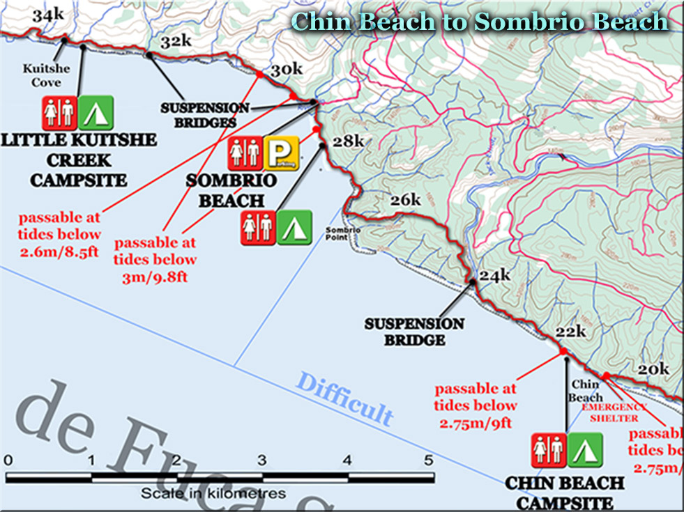
There are several beach cut-offs along the route that all multi-day hikers need to be aware of. This means that you have to time the tides to avoid getting cut off and be stuck by a high tide. This is the list provided by Parks Canada. If you are unfamiliar with tide heights in this area and what to expect, usually high tides only reach 3 metres/9.8 feet and low tides .4 metres/1.3 feet. In short, the times you can be cut-off due to tides is somewhat short so be aware of tides, but don't expect them to be a major inconvenience. These are the high tide cutoffs running from the Juan de Fuca trailhead starting point at the China Beach end of the trail. Bear Beach at kilometre 8.7 - passable below 3metre/9.8 foot tide. Chin Beach East at kilometre 20.6 and Chin Beach West - both passable at 2.75metres/9 foot tide. Sombrio Beach(East 28k and West-west at 30.2k) both passable at 3metre/9.8 foot tide. Sombrio Beach(West) at kilometre 29.6 - passable at 2.6metre/8.5 foot tide.
Juan de Fuca Trailhead to Bear Beach(0k-9k)
The Juan de Fuca Trailhead is at the easternmost end of the trail, closest to Victoria. There are two large parking areas here. One for the Juan de Fuca Trail and the other for the short hike to China Beach. If you are visiting for just a few hours, either or both trails are great to see. Both China Beach and Mystic Beach are beautiful to see, however Mystic Beach is a more varied and longer section of trail that crosses a suspension bridge. Mystic Beach is very pretty and Mystic Falls cascades over an abrupt cliff to the sand below. The often muddy trail to Mystic Beach takes you through deep coastal forest and is not too challenging. Most reach the beach in just over 30 minutes. If you arrive here on the weekend, you will usually find dozens of people picnicking and playing by the sea. Mystic Falls pour from a rapidly eroding cliff that ocean undercutting have eroded partial caves that are captivating to look at. Rocks in the ceiling crumble off easily and you feel as though you could spot a dinosaur bone jutting out everywhere you look. Recently a fossil bone from a previously unknown penguin-like bird was discovered just a few kilometres from here.
Beyond Mystic Falls the shoreline becomes impassable and you must walk west along the beach and past the beach access trail you hiked in on and find the next beach access point. This well marked access point ascends quickly into the forest and back on the beautiful Juan de Fuca Trail just past the 2k marker shown on the map above. The trail to Bear Beach is through the deep forest with occasional creek crossings and frequent stunning ocean views. There are three separate campsite areas to choose from at Bear Beach, all of them quite nice and spaced well apart. Plenty of fresh water sources pour down to the beach and there are pit toilets strategically an conveniently located. The campsite at Rosemond Creek has a beach cutoff just west of it. At high tide the water crashes against the cliffs here and only passable below 2.75 metres/9feet. Past this beach cutoff you will come to Clinch Creek and another lovely camping area. Named after a shipwreck here in 1860, the D.L. Clinch a schooner met its end here in November of that year. The third camping area is further along, just before Ledingham Creek. Another nice campsite with lots of fresh water sources and a pit toilet.
Bear Beach to Chin Beach(9k-21k)
This section of trail from Bear Beach to Chin Beach is very challenging with constant elevation change and lots of mud and creek crossings. Very difficult and very rewarding this section of trail finally emerges from the forest at Chin Beach. An emergency shelter is found at the eastern entrance to the beach and useful if cut off by yet another high tide cutoff point. Chin Beach is much more wild and remote feeling than Mystic Beach or China Beach. Lots of great campsite areas and plenty of beach access points make this area interesting and varied. All trail access points are well marked with old, usually brightly coloured buoys. Though you always have to be cautious about the tides, frequent signs guide the absentminded hiker to the correct route. Ascending back into the forest the Juan de Fuca Trail continues to Sombrio Beach.
Chin Beach to Sombrio Beach(21k-28k)
The section of the Juan de Fuca Trail between Chin Beach and Sombrio continues to be quite challenging. Nearly always zig-zagging left and right, up and down. Crossing numerous creeks. The beautiful suspension bridge over Loss Creek stretches high across, and above a wide chasm through the forest. A gap in the trees opens up to a marvellous view of the ocean. Further along the trail you reach Sombrio Point and a shockingly abrupt cliff with sensational views. The trail continues along the cliff edge for a few minutes more before finally dropping down to Sombrio Beach. Lots of excellent campsites are found at Sombrio as well as the occasional surfer out in the waves. Sombrio Beach is often frequented by bears to such a degree that the area is sometimes closed to campers. You will see notices along the trail warning of this if it happens and be able to plan accordingly. Sombrio Beach is a popular access point in the summer months and expect it to be busy on weekends.
Sombrio Beach to Parkinson Creek(28k-37k)
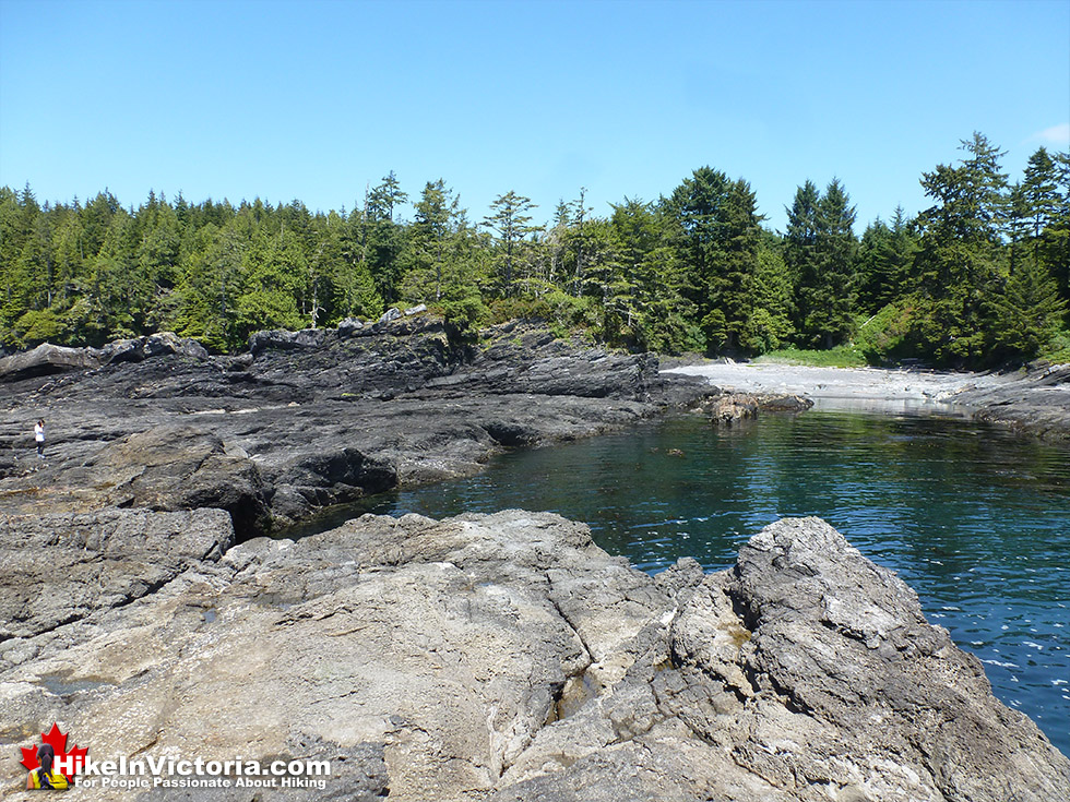
The trail from Sombrio Beach to Parkinson Creek starts off immediately wild and beautiful. Just as you enter the forest from the beach you encounter another characteristically Juan de Fuca Trail suspension bridge. This one takes you across Sombrio River and then the trail takes you back down to the beach. You can hike along the beach here at low tide, however there are several inland trails when the tide rises. The Juan de Fuca Trail is noticeably less difficult the further you hike from Sombrio Beach. There is another suspension bridge over Minute Creek and though the creek can be crossed along the beach, it is often quite a challenge to make it through. Kuitshe Creek has some nice spots to put up a tent nestled in the forest along the shore. Beyond Kuitshe Creek the trail continues inland to the parking lot at the Parkinson Creek trailhead.
Parkinson Creek to Botanical Beach(37k-46k)
The Juan de Fuca Trail from Parkinson Creek to Botanical Beach begins through the forest and across two bridges and eventually leading down to the beach. Beach walking along the shore with beautiful tide pools soon leads to another beach exit into the forest. The trail becomes luxuriously easy here with boardwalks that carry you over, instead of through the muddy sections. Pazant Creek is the next campsite you come across with several tent sites complete with tent platforms nestled in the trees. The trail continues through the forest here and just past Yuah Creek you will see a small trail leading to Providence Cove. A beautiful little cove and home to a long abandoned set of campsites used previous to the ones built at Payzant Creek. Back on the Juan de Fuca Trail towards Botanical Beach the trail becomes steadily easier. Botanical Beach is the beautiful end of the Juan de Fuca Trail with numerous tide pools teeming with marine life. There are two access trails to the parking lot here and you should be sure to continue to Botany Bay before exiting the Juan de Fuca Trail at the Botanical Beach trailhead.
Camping on the Juan de Fuca Trail
There are a wide range of camping and bivouacking options in Juan de Fuca Provincial Park. From the often crowded and commercial campground at China Beach to the more serene and idyllic campsites at Sombrio, Kuitsche Creek and Payzant Creek. For the more hardcore, serenity seeking hikers there are endless bivouacking options along this remarkable stretch of wilderness paradise. The huge vehicle accessible campground at China Beach costs $20 per party, per night is often crowded, however a perfect way to experience a classic Canadian campsite. Lots of beer drinking by campfires and possibly the most friendly and approachable people you will ever encounter. The campground is in a forested area just inland from China Beach and wonderfully organized and maintained. China Beach is a nice place to visit anytime of the year, however the campground is gated and closed in the off season, September 16th to May 12th. Walk-in campsites along the Juan de Fuca Trail are open year-round.
Sombrio Beach and Parkinson Creek have vehicle accessible camping as well, however they are effectively parking lots and therefore only usable by self-contained units only(backcountry fees apply - $10/person per night). There are several excellent campsites along the Juan de Fuca Trail that are open year-round. Mystic Beach, Bear Beach, Chin Beach and Sombrio Beach(East) have excellent beach sites. Forest campsites along the trail include Little Kuitsche Creek and Payzant Creek with limited beach access and fire restrictions. Backcountry camping information is posted at all the trailheads listing all the rules and registration info. $10 per adult/night(19 years and older). $5 per youth/night(13-18). Parking is included in your camping fee. Four persons per site, unless otherwise authorized. Please pay your camping fee at the self-registration fee station. Maximum length of stay is 14 days per calendar year. Check out time is 11am.
Self Registration Policy: Fees must be paid at the red vault prior to overnight stay. There are no fee vaults at the designated camping areas. The red vaults are located a trailhead parking lots. Complete permit envelope, place fee in envelope, remove receipt and parking stub, deposit sealed envelope in vault. Personal cheques are not accepted and considered as non payment. Park attendant will be in park to confirm registration and fee payment. Minimum fine for non-payment is $50.
Facilities in Juan de Fuca Provincial Park
There are hardly any modern facilities in Juan de Fuca Provincial Park. This is a wonderful bit of foresight that has kept this rainforest trail wild and remote feeling and partitioned from modernity. Throughout the park you will only find pit toilets and running water is only found from at the China Beach Campground. Pit toilets are at all the trailheads and all of the more frequented beaches. A few essential suspension bridges along the trail along with excellent trail signs and maps guide you through this remarkably untouched wilderness. It is advised to bring your own drinking water to the park or boil, filter or treat the water you drink. This advise generally goes unheeded along the trail where the chance of Beaver Fever(Giardasis) is vanishingly small. If you are visiting for just a day, bringing your own water is easy. If you are staying in the park longer you might want to bring aquatabs or some other water purification method for peace of mind.
Restrictions in Juan de Fuca Provincial Park
There are very few restrictions in Juan de Fuca Provincial Park owing to its large size and relative remoteness. Any restrictions in the park are effectively common sense. The park is very dog friendly, however the occasional sign proclaims that they must be on a leash at all times, you are responsible for their behavior and must dispose of their excrement. Due to the Juan de Fuca Trail being home to bears and cougars, there are some warnings in the park about potential dog and wildlife conflicts. Cougar sightings are extremely rare and bear sightings are somewhat infrequent. Campfires are welcome in the park made from driftwood and below the high tide mark. Cutting trees and snags from the forest, especially around the China Beach Campground is prohibited and a ticketable offence under the Park Act. Portable stoves are required at some campsites along the Juan de Fuca Trail, however you can almost always be able to find a safe area on the beach for a campfire.
Directions to the Juan de Fuca Trail
There are four main access trailheads for the Juan de Fuca Trail, all with clear signs along Highway 14. From Victoria China Beach is 70k(43.5 miles), Sombrio Beach 95k(59 miles), Parkinson Creek 100k(62 miles) and Botanical Beach 110k(68 miles). The trail can of course be hiked from either end or in parts. Starting at Botanical Beach and timing the tides correctly allows for a great way to start the trek as you can see the first five or so kilometres at the wonderful beach level. To hike the full trail in one direction you will want to park a vehicle at either end or arrange to be dropped off at one end. There is a bus service that specifically services the Juan de Fuca Trail and West Coast Trail and runs in the summer months May 1st to September 30th. The West Coast Trail Express is a good option if you don't have a car or want a lift from your car to the other end of the trail. Though the bus doesn't run often, it is surprisingly punctual and reliable.
The Juan de Fuca Trail is free for day-use visitors, however you will need to purchase a parking pass for your car. These are found at all the main trailhead parking lots. This is not a way to price gouge people, but rather an organized way to keep track of hikers in the park. Without this feature you may have a car parked for weeks and not know that the owners are lost or injured somewhere on the trail. With a day parking pass, missing hikers can be identified quickly. If you are staying in the park overnight you must purchase a multi-day camping permit also available at all main trailheads. You fill it out to indicate how many days you expect to be on the trail and a tear off receipt for the dash of your car. This receipt then acts as your multi-day parking pass. Whichever pass you plan to get, they are available at all the main trailheads via the easy to use self registration terminals. Currently the backcountry camping fees are $10/per night(kids 15 and younger $5/night). Vehicle camping at the China Beach Campground is only $20 per party per night and can be reserved online. Alternatively you can just show up, however the campsites full up quickly in the busy summer weekends and if you just show up they are available first come, first served.
There are several beach cut-offs along the route that all multi-day hikers need to be aware of. This means that you have to time the tides to avoid getting cut off and be stuck by a high tide. This is the list provided by Parks Canada. If you are unfamiliar with tide heights in this area and what to expect, usually high tides only reach 3 metres/9.8 feet and low tides .4 metres/1.3 feet. In short, the times you can be cut-off due to tides is somewhat short so be aware of tides, but don't expect them to be a major inconvenience. These are the high tide cutoffs running from the Juan de Fuca trailhead starting point at the China Beach end of the trail. Bear Beach at kilometre 8.7 - passable below 3metre/9.8 foot tide. Chin Beach East at kilometre 20.6 and Chin Beach West - both passable at 2.75metres/9 foot tide. Sombrio Beach(East 28k and West-west at 30.2k) both passable at 3metre/9.8 foot tide. Sombrio Beach(West) at kilometre 29.6 - passable at 2.6metre/8.5 foot tide.
Fort Rodd Hill is astonishingly beautiful and incredibly interesting as a tourist attraction in Victoria that most never see. This fact is amazing as it ...
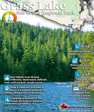
Grass Lake(aka Grasse Lake or Grassie Lake) is a moderately difficult trail to a beautifully remote lake far in the wilderness of Sooke. Popular for ...
The Juan de Fuca Trail is a beautiful wilderness trail that hugs the west coast of Vancouver Island between Jordan River(north of Sooke) and Port Renfrew. ...
Avatar Grove and Canada's gnarliest tree is an amazing thing to see and finding it is half the fun. The cute little town of Port Renfrew, know for it's ...
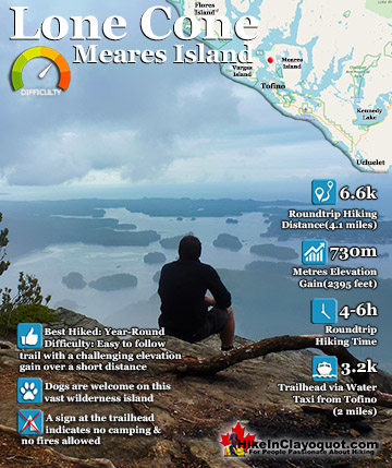
Lone Cone is the wonderful cone shaped mountain that dominates the skyline in Tofino. It is just 6k from Tofino on the north-western end of Meares Island. ...
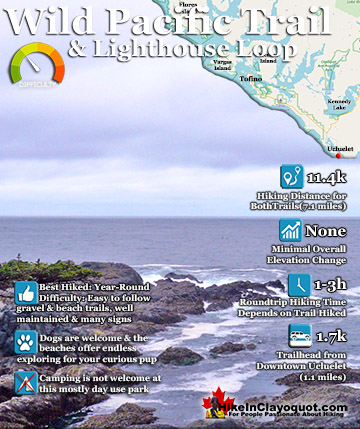
The Wild Pacific Trail is a must see on any visit to Pacific Rim National Park, Ucluelet and/or Tofino. Located in Ucluelet, the Wild Pacific Trail is ...
Meares Island was the centre of dispute in the 80's when the Nuu-chah-nulth protested Macmillan Bloedel's intent to log the island. The Nuu-chah-nulth ...
Hot Springs Cove is a wonderful day trip from Tofino. Lots of whale watching companies offer whale watching/hot springs tours for very reasonable prices. The ...