Victoria has a staggering number of hiking trails that almost always reach something amazing.. and radically different. From Goldstream Park's spawning salmon to the marvellous Goldstream Train Trestle. You can hike dozens of beautiful, coastal kilometres in Juan de Fuca Provincial Park and East Sooke Regional Park. Victoria is a hiker's paradise.
TheWestCoastTrail
The West Coast Trail traces a route along a 75 kilometre section of Vancouver Island's hostile west coast. The trail looks over the Graveyard of the Pacific, home to hundreds of shipwrecks over the centuries. The Graveyard of the Pacific necessitated the construction of the West Coast Trail to save lives from the frequent shipwrecks.
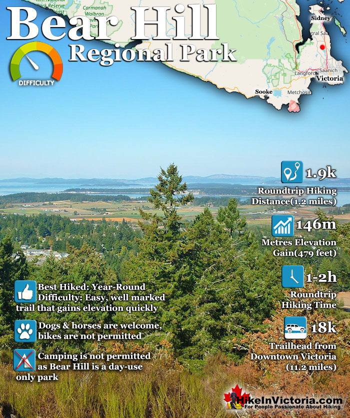
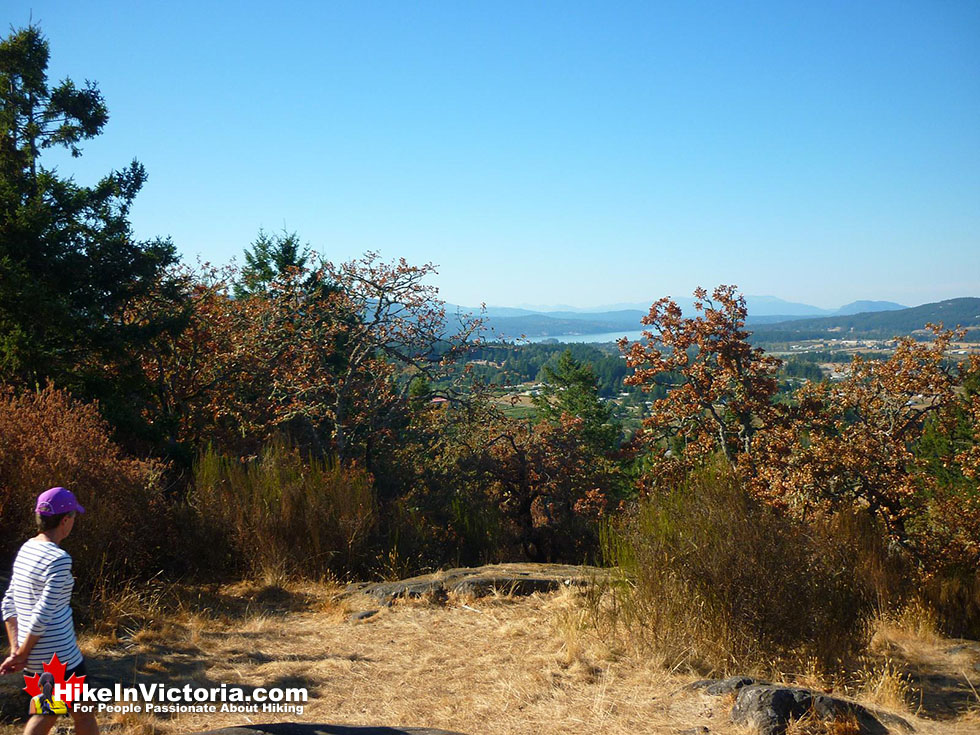
Bear Hill Regional Park is a nice hill trail, just north of Elk/Beaver Lake in Saanich. It is an easy 2k hike to the summit where the views are sensational. From the trailhead to the summit only takes about 20-30 minutes. High up on the Saanich Peninsula you can see the Gulf Islands and even the San Juan Islands in the United States. The technically active, and alarmingly close volcano, Mount Baker in Washington State is very visible as well on a clear day.
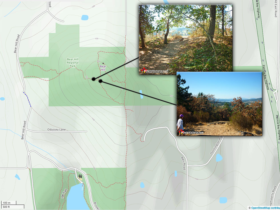
The trail to Bear Hill is easy and runs through a beautiful forest of Douglas fir trees that lead to the unexpected grove of Garry oak trees at the summit. The more you hike in Victoria, the more you notice these wonderful hiking trails to rocky hills/mountains. From Bear Hill's 220 metre elevation you may be able to spot other, distant Victoria mountains. If you look toward downtown Victoria you should be able to make out Mount Douglas and possibly Mount Tolmie. Mount Finlayson in Goldstream Park should be visible on a clear day as well far off the right of Victoria. Many Victoria mountains and hills have summit plaques that indicate the direction and names of visible summits. Bear Hill, unfortunately doesn't, however, Mill Hill and Mount Finlayson do. Bear Hill Regional Park connects with Elk and Beaver Lakes Regional Park making this small park into quite a larger area to hike. A beautiful 10k trail runs around Elk and Beaver Lakes. Take a look at the Bear Hill Regional Park map below for an idea of where the park is in relation to Elk/Beaver Lake Regional Park. It also shows the connecting trail to Elk and Beaver Lakes which then runs around these two beautiful Victoria lakes. There are no facilities such as washrooms at Bear Hill Regional Park, however the nearby Elk/Beaver Lake Park has washrooms as well as food vendors and a variety of water sport rentals available much of the year.
Directions to Bear Hill Regional Park
It is only 18 kilometres(11.2 miles) from downtown Victoria to the park and should take about 15-20 minutes to drive there. Leaving downtown Victoria take the Pat Bay Highway north from Victoria (as if going to the Ferry Terminal), after about 13k take the Sayward Rd Exit, then left on Hamsterley Rd, then right on Brookleigh Rd, turn left again to stay of Brookleigh Rd, right on Oldfield Rd, then right again onto Bear Hill Rd, look for the trailhead sign for Bear Hill Regional Park.
More Trails Near Bear Hill Regional Park
Elk/Beaver Lake Park is one of many beautiful lakeside trails in Victoria. From the convenient parking lot the trail is mostly flat, gravel or dirt, densely forested at times and runs around both Elk and Beaver Lakes to complete a 10k circuit. The park is very popular for swimming, picnicking, windsurfing, boating, fishing and rowing. Though it can get busy the large size of the park disperses people quite well. If you are running here you will find the trails around the lake peaceful and quiet even if the sandy beaches are crowded and noisy. Like other Regional Parks there are excellent toilet facilities at several points along this beautiful and relaxing trail. The beautiful wilderness hiking trails in Francis/King Regional Park take you past massive, old-growth Douglas Fir trees. Some estimated to be as old as 500 years and the Elsie King interpretive trail gives beautiful descriptions of the forest around you. There are over 11 kilometres of trails in the park and some of them connect to the adjacent, Thetis Lake Regional Park.
Thetis Lake Regional Park then connects to the beautiful Mill Hill Regional Park, combining these three beautiful parks into one, massive, interconnected hiking paradise. Francis King contains the massive old growth forest, Thetis the beautiful lakeside trails, and Mill Hill the wonderful mountain views out to the ocean around Victoria. Gowlland Tod is a beautiful park running along the Saanich Inlet. Accessible from Goldstream Park at one end and Brentwood Bay, near Buchart Gardens at the other. From beautiful ocean views of the inlet to wonderful mountain views from Mount Work, this park has a great variety of characteristically Victoria hiking. Mount Work is a popular hiking trail in Gowlland Tod and the most challenging trail at 5k from trailhead to summit.
Gowlland Tod Provincial Park is quite large, spread out and the trails so varied, that you feel far from the city. The trails and views to and along Finlayson Arm are amazing and breathtakingly serene. An amazing park, so convenient to Victoria. And much like most other Victoria area parks, astoundingly quiet and wild. Naturally peaceful and astoundingly beautiful. Lone Tree Hill Regional Park has a beautiful panoramic view from its summit. The hike is fairly short and relaxing at just 1.6k trailhead to summit. Expect to hike for under 30 minutes to reach the viewpoint. The views for such a short hike are quite amazing. You can see the distant Malahat, Victoria as well as the very distant Olympic Mountains in the US. Dogs are welcome in the park, however, bikes, camping and fires are not. From Victoria take Douglas Street and continue to the Trans Canada Highway, after 12k take exit 14 toward Langford/Sooke/Highlands, keep right at the fork and follow the signs for Millstream Rd N, after 8.2k look for the Lone Tree Hill Regional Park sign on your right. Mill Hill Regional Park is a well hidden though wonderfully short hike to amazing views of Victoria, Esquimalt and the Western Communities. The hike is only 15 minutes to the summit with a branching trail that leads to Thetis Lake Regional Park.
This is a remarkably seldom hiked park in Victoria. It is rare to see anyone on the trail or at the beautiful summit. The views are amazing. What makes them even more amazing is that the views look as though you are on a much higher mountain than the small and short hike that brought you to this great summit. The hike is only 15 minutes to the summit with a branching trail that leads to Thetis Lake Regional Park. Mount Douglas or Mount Doug as it's locally known is a remarkably easily accessible park with both 360 degree mountain views as well as a beautiful beach. The beach and mountain are connected both by trails and roads allowing for a quick and beautiful visit by car or a longer, interesting and varied hike on foot among the huge Douglas Fir and Cedar trees. Parking is available in four areas. At the summit of Mount Doug (accessible by car only after 12pm daily), near the shores of Cordova Bay, at the gate, at the base of the road to the peak as well as further along the park at Glendenning Road. Among the spider web of trails on Mount Doug there is quite an amazing cave. Long abandoned from the old mining days it runs nearly 20 metres from the tiny entrance. Don't forget to bring a flashlight. Mount Tolmie is another beautiful, easily accessed mountain in Victoria with 360 degree views. On a clear day you can spot Mount Baker far off in the distance in the US. There are some short trails and a huge, flat topped water reservoir to walk on. Mount Tolmie is located near the University of Victoria, Oak Bay and Beach Drive.
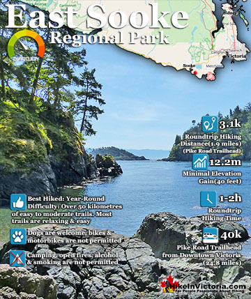
East Sooke Regional Park is a convenient and easily accessible way to experience the wild, west coast of Vancouver Island. Weather blasted rocky cliffs, ...
Huge Douglas-fir trees and tremendous views are the highlights of this beautiful Provincial Park just 30 minutes from downtown Victoria, near Sidney. ...
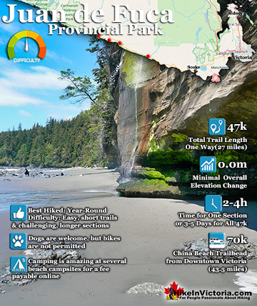
The Juan de Fuca Trail is a beautiful wilderness trail that hugs the west coast of Vancouver Island between Jordan River(north of Sooke) and Port Renfrew. ...
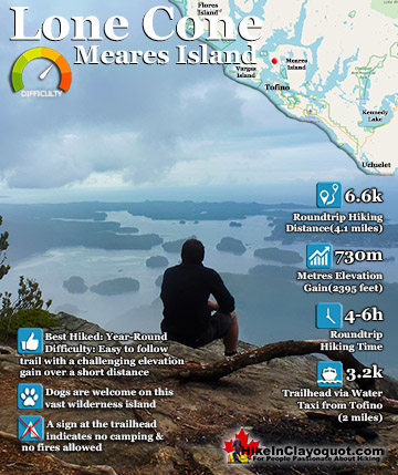
Lone Cone is the wonderful cone shaped mountain that dominates the skyline in Tofino. It is just 6k from Tofino on the north-western end of Meares Island. ...
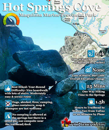
Hot Springs Cove is a wonderful day trip from Tofino. Lots of whale watching companies offer whale watching/hot springs tours for very reasonable prices. The ...
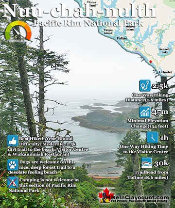
The Nuu-chah-nulth (aka the Wickaninnish Trail), has the amazing distinction among all the other beach hikes in the Tofino-Ucluelet corridor, in that it is flanked ...
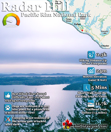
Radar Hill is definitely one of the Tofino sights not to be missed. It's a quick and easy walk to the top and the views are beautiful. Definitely one of ...